

Translated by Dr. Mengyi Jin
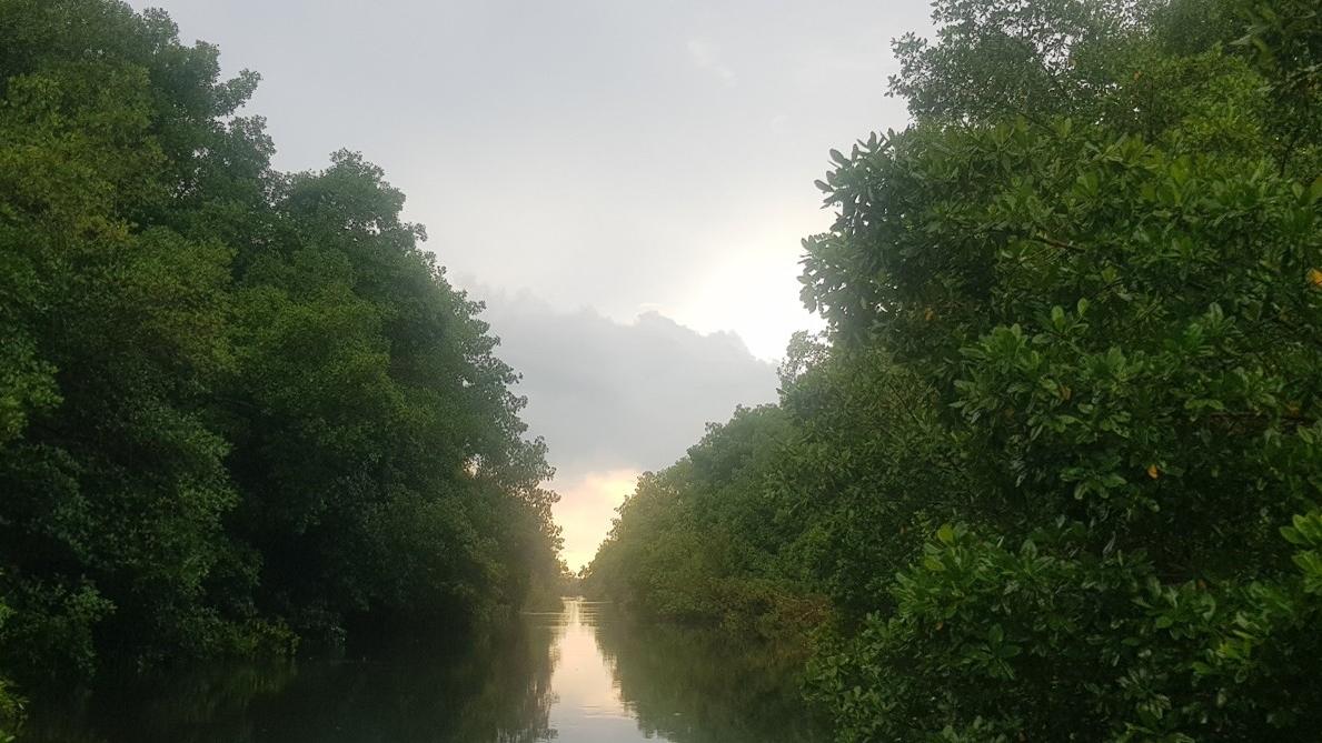
红树林因其自然景观和丰富的生物多样性而全球闻名,这一独特的生态系统在其所处的沿海环境中发挥着重要的作用。除了维持生物多样性,红树林还能有效抵御海岸侵蚀和风暴潮(Menendez et al. 2020),并具有很高的碳汇能力(Lovelock & Duarte 2019)。此外,红树林还有助于支持沿海居民生计, 维持海洋健康, 以及保护生物多样性(Dasgupta et al. 2022;Mallick et al. 2021)。尽管红树林在生态系统中具有关键作用,但据估算,自20世纪50年代以来,全球约有35%的红树林栖息地已被破坏或退化(Valiela et al. 2001)。受到人类活动和气候变化的影响,这一趋势预计仍将持续(Akram et al. 2023)。
尽管很多研究表明全球红树林流失的速度正在放缓(Bunting et al. 2022;Murray et al. 2022;Giri et al. 2011;Spalding et al. 2010),但国际自然保护联盟(IUCN 2024)的数据显示,全球仍有一半的红树林正面临威胁。《联合国气候变化框架公约》(UNFCCC)、《生物多样性公约》(CBD)以及《拉姆萨尔湿地公约》等一系列国际公约,都呼吁加强红树林的保护与修复。
利用地球观测技术绘制红树林地图
通过将红树林的分布与范围进行实时精细化制图,我们能够获取关于红树林变化的重要信息,尤其是红树林的损失情况(Bunting et al. 2023;Giri 2021)。这些地图有助于识别重点保护区域,还可以与其他数据图层(如红树林高度、物种类型、生长状况和生物量)结合使用,以估算碳储量(Hidayah et al. 2023;Hu et al. 2020)。随着空间技术的不断进步,地球观测数据正变得更加普及且成本更低。
| 卫星名称 | 传感器类型 | 空间分辨率 | 时间分辨率 | 数据来源链接 |
|---|---|---|---|---|
| Planet | PSB.SD | 3 米 | 每日更新 | https://planet.com/explorer/ |
| Sentinel-1 | 合成孔径雷达(SAR) | 10 米 | 每 6–12 天 | https://browser.dataspace.copernicus.eu/ |
| Sentinel-2 | 多光谱仪(MSI) | 10 米, 20 米 | 5 days | https://browser.dataspace.copernicus.eu/ |
| Landsat | OLI/TIRS (Landsat 8) | 30米波段 | 每16天 | https://earthexplorer.usgs.gov/ |
小岛面临的挑战
在小岛国家开展红树林制图工作面临一系列特有的限制与挑战,包括基础设施薄弱、天气条件不可预测、云层遮挡频繁以及资金支持有限等。小岛上的红树林通常分布范围较小,空间异质性较高,不同红树林物种与非红树林植被常常混杂在一起。这种情况会导致光谱污染或混合光谱反射,从而降低红树林边界划分以及物种分类的准确性(Pham et al. 2019)。因此,在小岛尺度上使用低、中分辨率的卫星影像并非最佳选择。热带和亚热带地区常年云层密布,不利于光学卫星成像。同时,小岛通常具有高度动态的潮汐现象,这会显著影响红树林在卫星遥感数据中的光谱特征和影像表现(Xia et al. 2018)。
此外,许多小岛国家在获取和使用地球观测技术上面临财政和技术上的困难,这成为制图项目规划与实施的重大障碍。近年来,低收入国家逐渐能够更加便捷地获取空间数据,从而更好地管理自然资源。小岛发展中国家(SIDS)通常需要更小尺度、更高分辨率的数据,这些数据以往因成本高昂而难以获得。而随着大量开源影像资源的出现,卫星影像正越来越多地被整合进国家级的制图与监测框架中(Avalon-Cullen et al. 2023;Soanes et al. 2021;Cherrington et al. 2020)。本文介绍的案例采用高分辨率地球观测影像对红树林物种的分布与覆盖范围进行制图,进一步展示了高分辨率数据在小尺度范围内绘制高精度地球特征的能力。
红树林物种制图
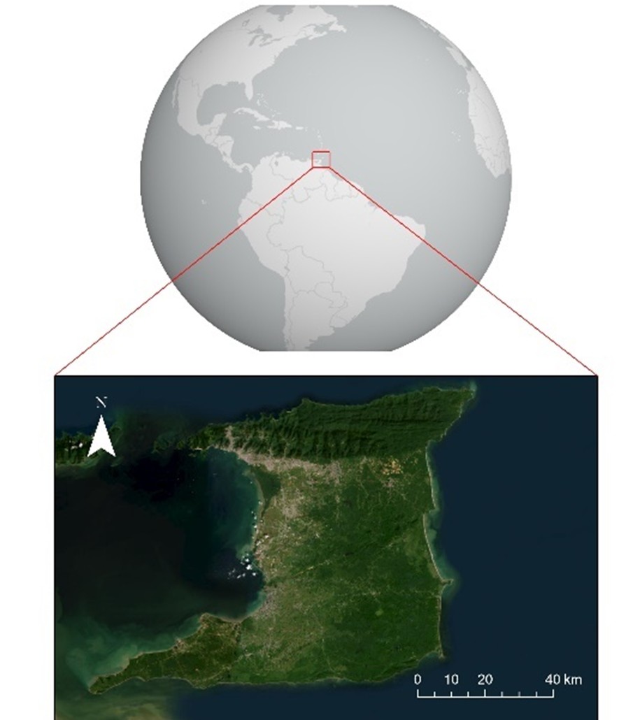
对主要红树林物种的分布与范围进行制图,对于应对气候变化、海岸开发以及其他人类活动带来的威胁具有重要意义(Sunkar et al. 2024;Twomey & Lovelock 2024)。这类地图能够提供关键生态指标,有助于理解生态系统的动态变化并制定保护策略。物种特异性制图还能反映生态系统对压力源(如水体污染或海平面上升导致的盐度变化)的响应情况(Zhao et al. 2020),从而为进一步规划和适应提供参考,以支持长期生存策略的制定。图 3 展示了加勒比海特立尼达岛卡罗尼沼泽地区的红树林物种分布图。
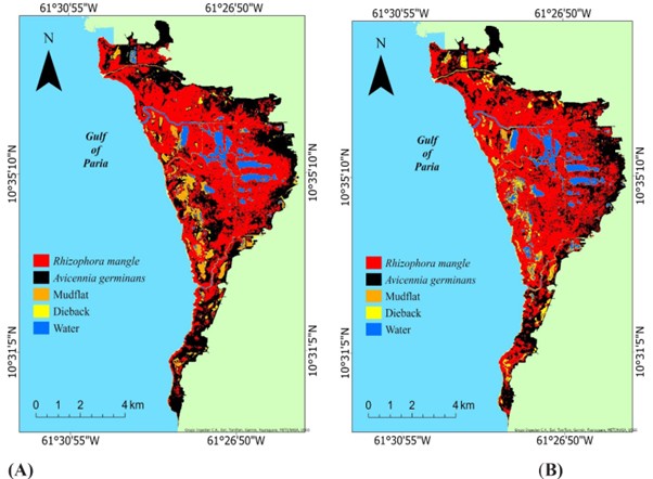
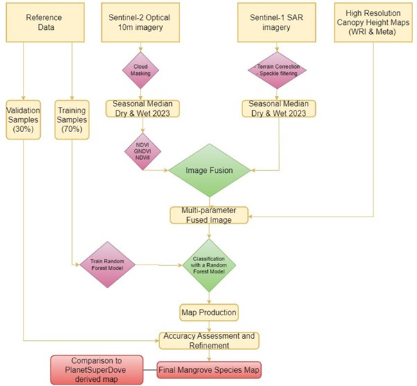
这两张季节性分布图基于多源数据融合的方法生成,其中包括 Sentinel-2 光学影像、Sentinel-1 合成孔径雷达(SAR)后向散射数据,以及由世界资源研究所(WRI)与 Meta制作的全球高分辨率冠层高度模型(CHM)中的树高数据。此外,为了提升对两种主要红树林物种的识别能力,还使用了归一化植被指数(NDVI)、归一化水体指数(NDWI)和绿色归一化植被指数(GNDVI)。图 4 展示了上述方法的整体流程。完整的方法描述详见 Ramsewak 和 Jagassar(2024)的研究。使用误差矩阵和独立的GPS 实地数据进行测试发现,该光学-雷达-CHM 分类产品的总体精度达到了 98.95%。
讨论
随着技术的进步,地球观测数据的获取变得更加容易,这显著提升了在较小尺度上开展红树林、物种及其他生态动态制图的能力。Planet 和 Sentinel 卫星星座的数据在小岛国家中发挥了关键作用,主要得益于多个可以免费获取这些数据的开源项目。由于红树林通常以较小的片状分布,彼此之间以及与其他植被或土地覆盖类型之间交错混杂(Yang et al. 2022),因此高分辨率数据对于在海岛上进行小尺度制图尤为重要。计划于 2025 年后期发射的多项卫星任务,如欧洲航天局的“哥白尼扩展计划”(ESA 2024)、美国国家航空航天局(NASA)的“地表生物与地质任务”(SBG)(Thompson et al. 2022)以及 NASA和ISRO 合作的“合成孔径雷达任务”(NISAR),都将进一步增强在小岛尺度上的遥感制图能力(NASA 2024)。
结论
综上所述,地球观测技术的持续进步将不断改进制图产品、预测模型和生态保护框架,从而更好地保护我们的陆地与海洋生态系统。对于低收入的小岛国家来说,具有较高空间分辨率和光谱分辨率的卫星影像正变得更加价格合理且容易获取。随着开源雷达数据的增加,这些数据集能够更高精度地捕捉包括红树林物种在内的关键生态指标,从而实现对这些重要生态系统更加动态、及时的监测。

Akram, H., Hussain, S., Mazumdar, P., Chua, K. O., Butt, T. E., and Harikrishna, J. A. 2023. "Mangrove Health: A Review of Functions, Threats, and Challenges Associated with Mangrove Management Practices." Forests 14, no. 9. https://doi.org/10.3390/f14091698.
Avalon-Cullen, C., Caudill, C., Newlands, N. K., and Enenkel, M. 2023. "Big Data, Small Island: Earth Observations for Improving Flood and Landslide Risk Assessment in Jamaica." Geosciences (Switzerland) 13 (3). MDPI. https://doi.org/10.3390/geosciences13030064.
Bunting, P., Hilarides, L., Rosenqvist, A., Lucas, R. M., Kuto, E., Gueye, Y., and Ndiaye, L. 2023. "Global Mangrove Watch: Monthly Alerts of Mangrove Loss for Africa." Remote Sensing 15 (8). https://doi.org/10.3390/rs15082050.
Bunting, P., Rosenqvist, A., Hilarides, L., Lucas, R. M., Thomas, N., Tadono, T., Worthington, T. A., et al. 2022. "Global Mangrove Extent Change 1996–2020: Global Mangrove Watch Version 3.0." Remote Sensing 14 (15): 3657. https://doi.org/10.3390/rs14153657.
Cherrington, E. A., Griffin, R. E., Anderson, E. R., Hernandez Sandoval, B. E., Flores-Anderson, A. I., Muench, R. E., Markert, K. N., et al. 2020. "Use of Public Earth Observation Data for Tracking Progress in Sustainable Management of Coastal Forest Ecosystems in Belize, Central America." Remote Sensing of Environment 245. https://doi.org/10.1016/j.rse.2020.111798.
Dasgupta, R., Hashimoto, S., and Saito, O. 2022. "Fostering Mangrove Ecosystem Services for a Resilient Future for the Asia-Pacific Region: A Knowledge Synthesis." In Assessing, Mapping and Modelling of Mangrove Ecosystem Services in the Asia-Pacific Region, edited by R. Dasgupta, S. Hashimoto, and O. Saito. Science for Sustainable Societies. Singapore: Springer. https://doi.org/10.1007/978-981-19-2738-6_16.
European Space Agency (ESA). 2024. Accessed January 15, 2025. https://www.esa.int/Applications/Observing_the_Earth/Copernicus/Future_….
Giri, C., Ochieng, E., Tieszen, L. L., Zhu, Z., Singh, A., Loveland, T., Masek, J., and Duke, N. 2011. "Status and Distribution of Mangrove Forests of the World Using Earth Observation Satellite Data: Status and Distributions of Global Mangroves." Global Ecology and Biogeography 20 (1): 154–159. https://doi.org/10.1111/j.1466-8238.2010.00584.x.
Giri, C. 2021. "Recent Advancement in Mangrove Forests Mapping and Monitoring of the World Using Earth Observation Satellite Data." Remote Sensing 13 (4): 1–6. https://doi.org/10.3390/rs13040563.
Hidayah, Z., Rachman, H. A., and As-Syakur, A. R. 2022. "Mapping of Mangrove Forest and Carbon Stock Estimation of East Coast Surabaya, Indonesia." Biodiversitas 23 (9): 4826–4837. https://doi.org/10.13057/biodiv/d230951.
Hu, T., Zhang, Y. Y., Su, Y., Zheng, Y., Lin, G., and Guo, Q. 2020. "Mapping the Global Mangrove Forest Aboveground Biomass Using Multisource Remote Sensing Data." Remote Sensing 12 (10). https://doi.org/10.3390/rs12101690.
IUCN. 2024. The IUCN Red List of Threatened Species. Version 2024-2. Accessed December 29, 2024. https://www.iucnredlist.org.
Lovelock, C. E., and Duarte, C. M. 2019. "Dimensions of Blue Carbon and Emerging Perspectives." Biology Letters 15: 20180781. https://doi.org/10.1098/rsbl.2018.0781.
Mallick, B., Priodarshini, R., Kimengsi, J. N., Biswas, B., Hausmann, A. E., Islam, S., Huq, S., and Vogt, J. 2021. "Livelihoods Dependence on Mangrove Ecosystems: Empirical Evidence from the Sundarbans." Current Research in Environmental Sustainability 3. https://doi.org/10.1016/j.crsust.2021.100077.
Menéndez, P., Losada, I. J., Torres-Ortega, S., Narayan, S., and Beck, M. W. 2020. "The Global Flood Protection Benefits of Mangroves." Scientific Reports 10 (1). https://doi.org/10.1038/s41598-020-61136-6.
Murray, N. J., Worthington, T. A., Bunting, P., Duce, S., Hagger, V., Lovelock, C. E., Lucas, R., et al. 2022. "High-Resolution Mapping of Losses and Gains of Earth’s Tidal Wetlands." Science 376 (6594): 744–749. https://doi.org/10.1126/science.abm9583.
National Aeronautics and Space Administration (NASA). 2024. Accessed January 14, 2025. https://nisar.jpl.nasa.gov/news/122/nasa-isro-aiming-to-launch-nisar-mi….
Pham, T. D., Yokoya, N., Bui, D. T., Yoshino, K., and Friess, D. A. 2019. "Remote Sensing Approaches for Monitoring Mangrove Species, Structure, and Biomass: Opportunities and Challenges." Remote Sensing 11 (3). https://doi.org/10.3390/rs11030230.
Ramsewak, D., and Jagassar, A. 2024. "Integrating a High-Resolution Canopy Height Model with a Sentinel-1/2 Fused Product in Google Earth Engine for Mangrove Species Mapping in the Caroni Swamp." Caribbean Journal of Science 54 (2): 428–442. https://doi.org/10.18475/cjos.v54i2.a21.
Soanes, L. M., Pike, S., Armstrong, S., Creque, K., Norris-Gumbs, R., Zaluski, S., and Medcalf, K. 2021. "Reducing the Vulnerability of Coastal Communities in the Caribbean Through Sustainable Mangrove Management." Ocean and Coastal Management 210. https://doi.org/10.1016/j.ocecoaman.2021.105702.
Spalding, M., Kainuma, M., and Collins, L. 2010. World Atlas of Mangroves (Version 3.1). A collaborative project of ITTO, ISME, FAO, UNEP-WCMC, UNESCO-MAB, UNU-INWEH, and TNC. London: Earthscan. https://doi.org/10.34892/w2ew-m835.
Sunkur, R., Kantamaneni, K., Bokhoree, C., Rathnayake, U., and Fernando, M. 2024. "Mangrove Mapping and Monitoring Using Remote Sensing Techniques Towards Climate Change Resilience." Scientific Reports 14 (1). https://doi.org/10.1038/s41598-024-57563-4.
Twomey, A., and Lovelock, C. 2024. "Global Spatial Dataset of Mangrove Genus Distribution in Seaward and Riverine Margins." Scientific Data 11 (1). https://doi.org/10.1038/s41597-024-03134-1.
Thompson, D. R., Basilio, R., Brosnan, I., Cawse-Nicholson, K., Chadwick, K. D., and Guild, L. 2022. "Ongoing Progress Toward NASA's Surface Biology and Geology Mission." IGARSS 2022 - 2022 IEEE International Geoscience and Remote Sensing Symposium, Kuala Lumpur, Malaysia, 2022, 5007–5010. https://doi.org/10.1109/IGARSS46834.2022.9884123.
Valiela, I., Bowen, J. L., and York, J. K. 2001. "Mangrove Forests: One of the World’s Threatened Major Tropical Environments." BioScience 51 (10): 807–815. https://doi.org/10.1641/0006-3568(2001)051[0807:MFOOTW]2.0.CO;2.
Xia, Q., Qin, C. Z., Li, H., Huang, C., and Su, F. Z. 2018. "Mapping Mangrove Forests Based on Multi-Tidal High-Resolution Satellite Imagery." Remote Sensing 10 (9). https://doi.org/10.3390/rs10091343.
Yang, G., Huang, K., Sun, W., Meng, X., Mao, D., and Ge, Y. 2022. "Enhanced Mangrove Vegetation Index Based on Hyperspectral Images for Mapping Mangrove." ISPRS Journal of Photogrammetry and Remote Sensing 189: 236–254. https://doi.org/10.1016/j.isprsjprs.2022.05.003.
Zhao, X., Rivera-Monroy, V. H., Wang, H., Xue, Z. G., Tsai, C. F., Willson, C. S., Castañeda-Moya, E., and Twilley, R. R. 2020. "Modeling Soil Porewater Salinity in Mangrove Forests (Everglades, Florida, USA) Impacted by Hydrological Restoration and a Warming Climate." Ecological Modelling 436. https://doi.org/10.1016/j.ecolmodel.2020.109292.