Modified Normalized Difference Water Index (MNDWI)

"The Modified Normalized Difference Water Index (MNDWI) uses green and SWIR bands for the enhancement of open water features. It also diminishes built-up area features that are often correlated with open water in other indices.

MNDWI = (Green - SWIR) / (Green + SWIR)

    Green = pixel values from the green band
    SWIR = pixel values from the short-wave infrared band

Reference: Xu, H. "Modification of Normalised Difference Water Index (NDWI) to Enhance Open Water Features in Remotely Sensed Imagery." International Journal of Remote Sensing 27, No. 14 (2006): 3025-3033." (ESRI, 2018)

Sources

"Indices gallery". ArcGIS Pro, ESRI. 2018. 
http://pro.arcgis.com/en/pro-app/help/data/imagery/indices-gallery.htm.
Accessed February 1, 2019.

Related Content

Article

Counting every drop: How space technology is rewriting water accounting and auditing

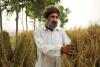
At sunrise in Bundelkhand, Northern India, farmer Ramesh Patel walks across a cracked wheat field, where the delayed and weak monsoon has left his crops wilting and wells running dry. Over the past five years, wells have sunk several meters, and groundwater levels in the region have fallen steadily for more than two decades (CGWB 2021; Niranjannaik et al. 2022). He is not alone: farmers, water managers, industries, and hydropower operators around the world face the same urgent question—how much water do we really have?  

Space-based Solution